Blame construction of earthen embankment through Tolleaband body for inundation of road near bypass
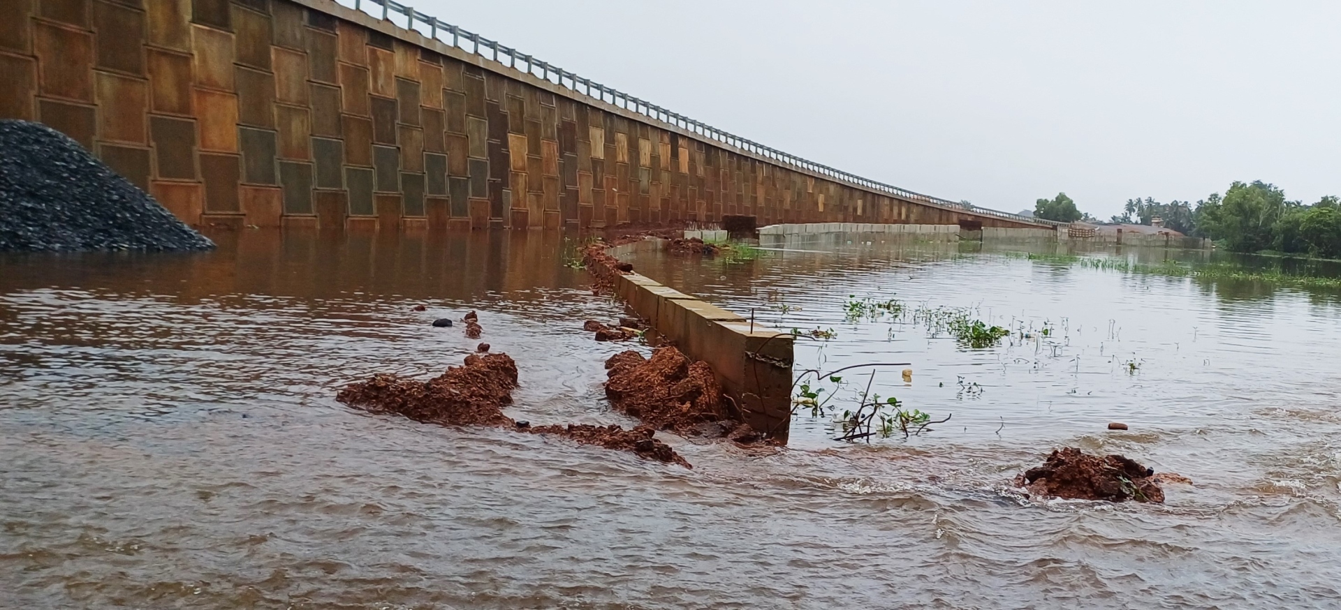
The huge earthen embankment running across the Tolleband water body to make way for the western bypass.
MARGAO
What could be the possible reasons behind the inundation of large tracts of the flood plains of river Sal and slow drainage of the flood waters in Benaulim, Mungul, Seraulim and Nuvem along the alignment of the Western bypass – is it the huge earthen embankment raised by the PWD right through the flood plains to make way for the bypass or is it simply the silted river Sal that has come in the way of quick drainage of the flood waters?
Did any of the officials, representing the PWD, National Highways, Water Resources Department, Agriculture, Bio-diversity, besides revenue officials descend in these villages to conduct an inspection of the flooding to understand the factual position and suggest measures for the quick drainage of the flood waters?
These and other questions have come to haunt villagers as well as farmers for a simple reason that while the rains have subsided a bit during the weekend, the water catchment areas and the flood plains in these villages continues to lie submerged under water.
Locals in the know say it’s not uncommon to find the water catchment areas and wetlands of river Sal inundated with water during the monsoons. What, however, has caused concern amongst the local farmers and villagers is the slow drainage of the flood waters coupled with the reverse flow of water in the villages of Seraulim and Mungul.
Villagers and farmers had waged a sustained battle demanding construction of the western bypass on stilts along the 2.5 km stretch of the bypass passing through Seraulim, Mungul and Benaulim. While the government later agreed to build the bypass on stilts along the 900 metre stretch from Seraulim to Mungul, the balance stretch passing through Benaulim is being built via land filling to raise an earthen embankment.
A visit to Tolleaband-Benaulim earlier last week when the roads were submerged under water revealed that the huge earthen embankment divided the water body into two halves, with the service road on the western side submerged under water.
Locals suspect that the construction of the huge earthen embankment through the Tolleaband body is the main cause behind the inundation of the road near the bypass for two days. A villager Rudolf Barretto says that is specifically for this reason that the villagers and farmers were demanding construction of the bypass on stilts. “It is a known fact that why you build something in a water body, more so in a water catchment area, the water will get displaced and overflow. This is what we have seen in the last one week with the water not draining out quickly”, he said.
Rudolf recalled that the Water Resources Department had in its reports cautioned the government to go for the bypass on stilts, but in vain. “If you have a glance at the WRD reports, it is clear that the officials had foreseen this situation and hence had batted for bypass on stilts”, he said.
Goa Forward Chief Vijai Sardesai drew attention of the House to the issue of inundation of low lying areas of Benaulim, Mungul, Seraulim and Davondem as he made a plea to the government to at least implement the recommendations made by Central expert R K Pandey. “Since the government has bulldozed its way by building the western bypass sans stilts, at least Pandey’s recommendations should be implemented to mitigate the effects of flooding in the low lying areas along the bypass”, Sardesai said.