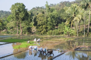
Floods being the most common natural disaster, people have, out of experience, devised many ways of coping with them
According to the Vice Chairman of the National Disaster Management Authority on January 17, 2008: “Flooding in the cities and the towns is a recent phenomenon caused by increasing incidence of heavy rainfall in a short period of time, indiscriminate encroachment of waterways, inadequate capacity of drains and lack of maintenance of the drainage infrastructure.”
In the National Disaster Management Guidelines which have been published by the National Disaster Management Authority pertaining to the management of floods as early as January, 2008, the most relevant observations were:
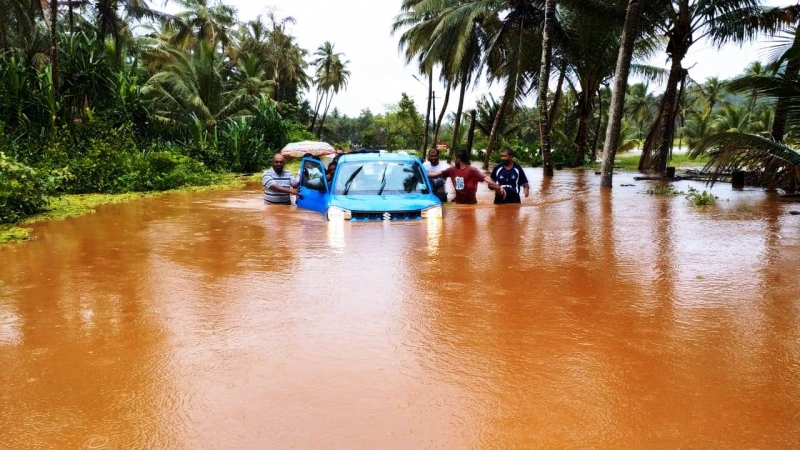
Floods have been a recurrent phenomenon in India and cause huge losses to lives, properties, livelihood systems, infrastructure and public utilities.
India’s high risk and vulnerability is highlighted by the fact that 40 million hectares out of a geographical area of 3,290 lakh hectares is prone to floods.
On an average every year, 75 lakh hectares of land is affected, 1,600 lives are lost and the damage caused to crops, houses and public utilities is Rs 1805 crore due to floods.
The maximum number of lives (11,316) were lost in the year 1977. The frequency of major floods is more than once in five years.
Floods have also occurred in areas, which were earlier not considered flood prone.
Eighty per cent of the precipitation takes place in the monsoon months from June to September.
The rivers bring heavy sediment load from the catchments. These, coupled with inadequate carrying capacity of the rivers are responsible for causing floods, drainage congestion and erosion of river banks.
In the same NDMA 2008 guidelines, the chapter on Flood Prevention, Preparedness and Mitigation elucidates:
Floods being the most common natural disaster, people have, out of experience, devised many ways of coping with them. However, encroachments into the flood plains over the years has aggravated the flood problem and a need to take effective and sustained FM measures has been felt (National Disaster Management Authority, 2008, pg. 21).
Capacity development
and flood response
The central government and the state governments are required to take steps for capacity development for taking effective and sustainable preventive, preparatory and mitigative measures in pre-floods stage and effective and prompt response during- and post-floods stages.
Activities for minimising
flood risk and losses
Phase-I
These activities include identification and marking of flood prone areas on maps, preparation of close contour and flood vulnerability maps, formulating plans for expansion and modernisation of flood forecasting and warning systems, identification of priority flood protection and drainage improvement works, identification of reservoirs for review and modification of operation manuals and rule curves and undertaking special studies on problems of river erosion.
Phase-II
These include implementation of the schemes for expansion and modernisation of the flood forecasting and warning network, execution of flood protection and drainage improvement schemes, modification and adoption of revised reservoir operation manuals, enactment and enforcement of flood plain zoning regulations and planning and preparation of Detailed Project Reports (DPRs) for storage reservoirs and implementation of the schemes for real-time collection of hydro-meteorological data on rivers.
Phase-III
Implementation of activities, which include construction of dams and catchment area treatment (CAT) works in India as well as neighboring countries, is likely to take considerable time as they entail major environmental, social, inter-state and international implications. These need careful study and interaction with the stakeholders.
Recurring activities
These activities which include inspection of dams, embankments and other structural measures, execution of restoration and strengthening works and expansion and modernisation of flood forecasting and warning systems, are to be taken on a regular basis for ensuring the effectiveness and sustainability of various measures for minimising flood risk. (National Disaster Management Authority, 2008, pg. 23).
Flood vulnerability
mitigative strategy
The World Bank in its feature story on August 17, 2023 entitled: “India: Managing the Complex Problem of Floods and Droughts” has put forward the EPIC Response framework to better manage these climate extremes. It emphasizes that floods and droughts be addressed as different ends of the same spectrum, and the whole of society be involved in the response – including the government, private sector, local government, academia, and civil society (World Bank, 2023).
Currently, the framework is now being piloted in India’s flood-prone state of Assam, along with a new tool that enables various agencies to assess the status of their flood and drought protection programmes, identify where collaboration can be enhanced, and track progress over time (World Bank, 2023).
As it has been appropriately opined by the World Bank (2023): “It depends on how society manages these climatic extremes. While national governments tend to deal with them in a siloed manner, what is needed is a paradigm shift in the way these events are managed altogether. It is a complex problem that requires a multi-sectoral approach to reduce the risks and impacts.”
Given the urgency of staying ahead of the changing climate, the World Bank, with support from Deltares, a Netherlands-based research institute, has put forward a new perspective to better manage these risks – the EPIC Response framework (Enable, Plan, Invest, Control).
To demonstrate the applicability of the EPIC Response framework in other Indian states, a workshop, co-organized by the Indian Water Partnership and the World Bank, was held in New Delhi in April 2023.
While these states - Assam, Bihar, Karnataka, Kerala and Odisha - face many common challenges, they have different climatic, economic, and social conditions.
The tool is a decision support system that enables various agencies to assess the status of their hydro-climatic risk management systems, identify areas where programme components can be strengthened, ascertain where collaboration can be enhanced, and track progress over time.
The results can facilitate a policy dialogue to generate a common understanding of their programmes’ status, as well as the challenges and opportunities for enhancing flood and drought risk management systems (World Bank, 2023).